Posts

Formal Introduction to our Project

Diurnal temperature range is the temperature variation that occurs throughout daylight hours (from sunrise to sunset). They are patterns because, generally speaking, they are the same from day to day. Several factors can affect the temperature variations. The length of the day is an obvious one, if the sun is heating the area for a longer period of time then the ambient temperature will naturally continue to increase over time, increasing the temperature variation. Along the same vein as the day length is cloud coverage. The clouds prevent the sun from heating the earth as much during the day while also preventing heat from escaping during the night, decreasing the variation. Ambient humidity and proximity to bodies of water are a major way that solar heat is absorbed. Water serves as a very effective heat sink and is able to absorb a lot of solar radiation before increasing in temperature. Once it has absorbed a lot of heat, it will remain at a more consistent temperature because ...
Diurnal Heat Patterns: Research and Training on the m600

Image
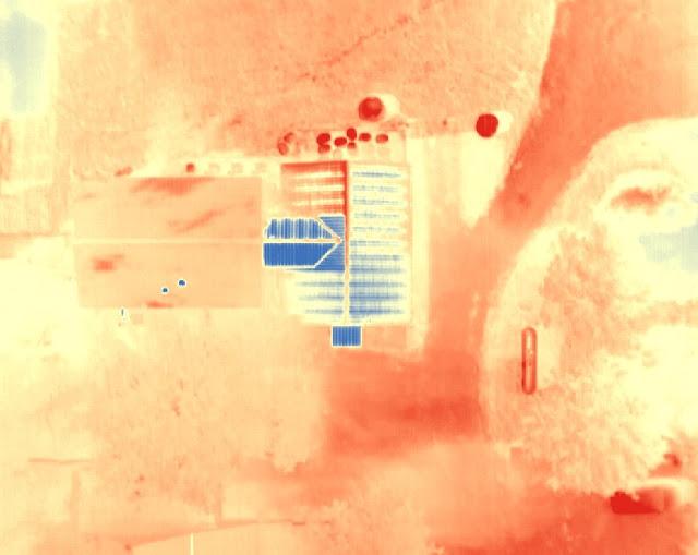
Research To increase our understanding of our topic, we have set to create an annotated bibliography with scholarly sources pertaining to the topics of diurnal temperature patterns, remote sensing, removal of noise in thermal imagery, and applications of thermal imagery in UAVs (among other topics) The culmination of our research can be found here What did we do? This week is the first week that we got to fly the m600 system. Due to the extensive nature of our data collection procedure, we thought it prudent to have a smaller outing to sort out any problems before we committed to a full day (sunrise to sunset) of data collection. Our main goal was getting trained on the M600 and learning how to use the XT2 thermal sensor.  After ensuring that the team was capable of flying the m600 we set up a simple mission that captured the buildings and the gravel parking of the Purdue Wildlife Area. In order to fit a flight into a single battery life, we set the overlap of the ...

Diurnal Heat Patterns Project Details

Image
Description of Project: Our project is the capture and analysis of diurnal heat patterns using UAS data and GIS software. The project will consist of first collecting thermal images of an area over several intervals throughout the day. Then we will combine the images into a composite image for ease of viewing and perform analysis on the collected data as a whole. This process will be repeated for multiple different areas of land so that we may see and compare the effect of diurnal heat patterns on different types of structures and land masses. Challenges: There are numerous challenges with completing a project of even as relatively low scope as this one. First among them is scheduling dates and times that the entire group is able to meet up . Due to the nature of the data collection procedure and the need for the entire team to be present, it will be difficult to arrange a day where everyone is capable of being present for every flight since it will include flights throughout t...

AT409 Capstone Project: Detection and Analysis of Diurnal Heat Patterns through UAS Data

Project Description: Jarrett, Luke, and Tim have decided to utilize thermal imagery for studying the diurnal heat patterns that occur throughout the day. We will be flying a thermal camera over an area and measuring the temperature of the ground, buildings, and water to see the different effects that different materials have on temperature exchanges throughout the day.  The flights will take place in several locations with different land features to see how heat patterns change from early morning to night. Our deliverable items will include a thermal map of a given area from 4-5 different flights at regular intervals throughout the day. The map will include land features such as hills and bodies of water as well as buildings and other man made structures. Roles and Responsibilities: Luke: Pilot in Command Flying the platform Pre and Post-flight checklists Checking out equipment Develop flight plan Charging batteries Safety management Luke will be the primary p...

Open Source GiS

Image
For the open source GIS lab we took the same task from a previous assignment and did it in QGIS instead of ArcMap or Pix4D. It was determined that, since Esri is so expensive, it would be prudent to learn the basics of open source GIS, which can be found for free. To facilitate this lesson, Dr. Christina Hupy was brought in to teach a lesson on QGIS. Figure 1 can explain the gist of the lesson. Figure 1: Open source volumetrics We used open source tools in QGIS to measure the volumes of piles in a quarry. An important distinction between Esri and QGIS is that in QGIS every tool is created in open source and even tools that already exist can be recreated and improved upon. This creates a bit of redundancy depending on the task you are performing but it also gives a lot of options. It seems to me that the QGIS is a very good tool to use and doesn't seem inherently inferior to Esri with the exception of Esri being more user friendly. Once someone is able to adequately navi...

Martell Forest Outing #2

Image
The second outing to Martell Forest after the disastrous ending to the first one. Since many of the notes overlapped I did not take as many as the first time. This time around, instead of being in the team that helped to set up the UAS, I was in the team that placed the GCP in strategic locations around the mission area, and thus my notes are more focused around that. Figure 1: The M600 takes flight Figure 2: Jasper, Lucas, and Hupy inspecting the gimbal Field Notes: GCP Placement: use different elevations 1st - 217 near dirt and rock pile on the road 2nd - 943 Next to road and shed 3rd - 491 Next to four cages 4th - 142 along tree edge sw corner clearing 5th - 500 along tree edge se corner 6th - 360 se . Corner bt tall grass and tree 7th - 206 along the tall grass nw of last one 8th - 420 middle middle 9th - 034 north of tall grass on east side 10th - 747 near truck. East of truck New Drone M600 Oblique 60 degrees camera angle Zenmuse x5 Rolling shutter Shutter priori...

UAS Bramor Mission Planning

Image
Introduction Mission planning is the preparation, information gathering, and checklists that take place before a mission begins. An important aspect of this phase is the distinction of the level of autonomy that the UAS will have. A more autonomous mission will likely have more of a focus on planning because there is less direct control over the UAV and thus you are unable to react as readily to unpredicted situations. Check-lists are a major part of pre-flight planning. A checklist will help ensure that all the necessary steps are completed and done in order, removing the chance that you could simply forget a step. Working with the C3P software For the first part of this lab we were asked to create a couple missions in varying conditions. The first example was a mission that followed along the length of a road as seen in Figure 1. Figure 1: Road Mission That mission was created in the Bramor Test Fields in Slovenia. Because it the mission takes place in a flat area, the...